
 commons.wikimedia.org on Google
The most significant archaeological discoveries of the next decade probably won't come from a desert excavation or a jungle survey. They'll come from the seafloor. Advances in underwater robotics, sonar mapping, and DNA analysis have converged at a moment when funding and public interest in maritime archaeology are both rising, producing a run of discoveries that would have been technically impossible ten years ago. The ocean, which covers 71 percent of the Earth's surface, has always been the largest unexplored archive of human history. We're finally starting to open it.
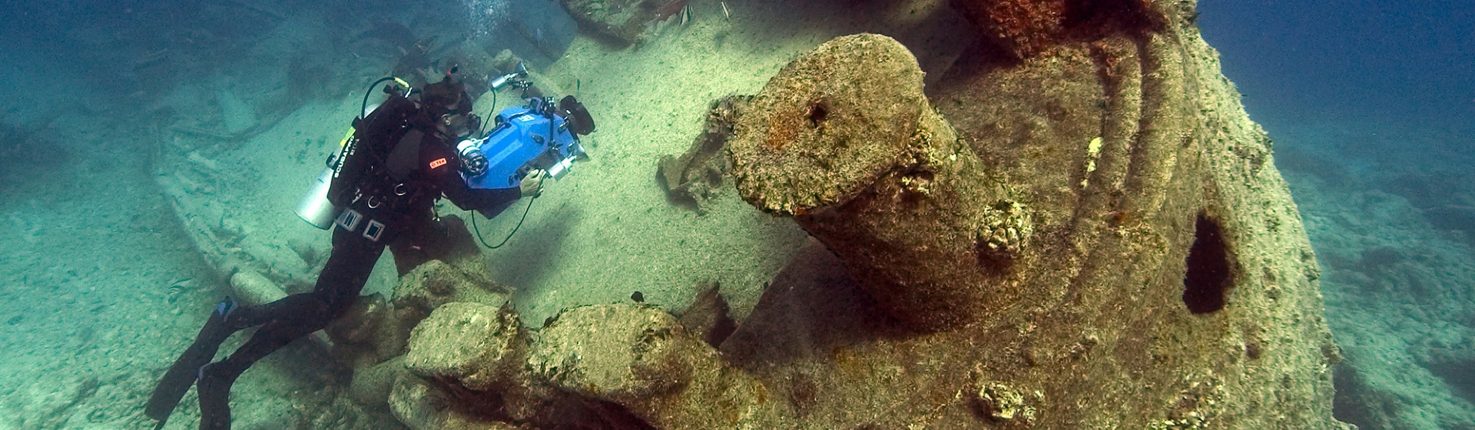
What makes this moment different from earlier eras of underwater exploration is the democratization of the technology. Deep-sea remotely operated vehicles, once the exclusive tools of military and oil industry contractors, have become accessible to academic research teams. Side-scan sonar and multibeam bathymetry can now produce detailed maps of the seafloor at a fraction of what it cost in the 1990s. And environmental DNA sampling, which extracts biological and organic material directly from seawater, is beginning to reveal the presence of ancient human activity without requiring physical excavation at all. The barrier between curiosity and discovery has never been lower.
The Seafloor Preserves What Land Cannot
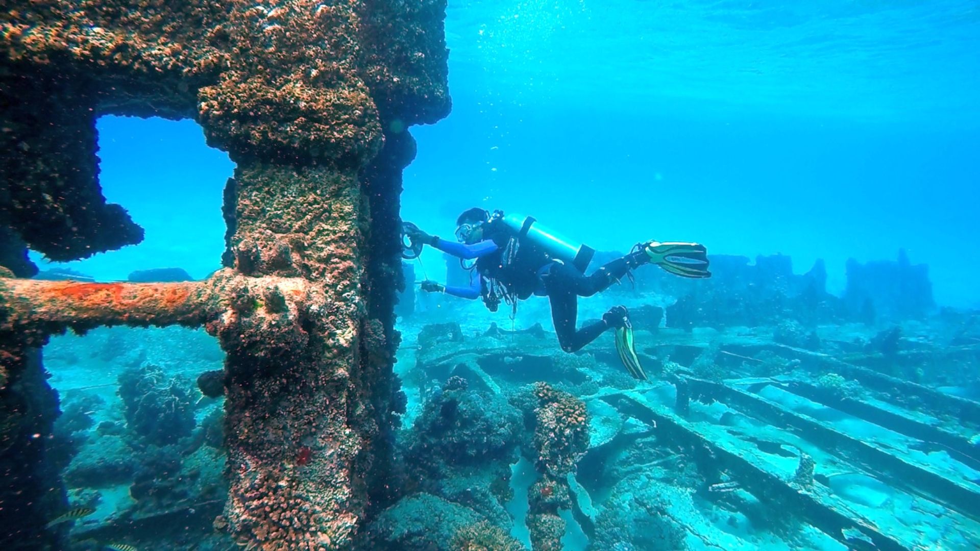
Underwater sites offer conditions that terrestrial archaeologists can only envy. Below the thermocline, where cold, oxygen-poor water limits microbial activity, organic materials that would rot within years on land can survive for millennia. Wood, rope, leather, textiles, and human remains have all been recovered from deep-water wrecks in states of preservation that defy expectation. The Black Sea Maritime Archaeology Project, which ran from 2015 to 2019, identified over 60 shipwrecks in the Black Sea's anoxic deep waters, including a Greek trading vessel dating to around 400 BCE with its mast, rudder, and rowing benches still intact. It was described by project researchers as the best-preserved ancient shipwreck ever discovered.
The preservation argument extends beyond individual wrecks. Entire landscapes swallowed by rising sea levels at the end of the last Ice Age now sit on continental shelves, undisturbed by the plowing, development, and erosion that have destroyed so much of the terrestrial record. Doggerland, the landmass that once connected Britain to continental Europe before being inundated roughly 8,000 years ago, has yielded tools, bones, and plant material from the North Sea seabed that are actively reshaping understanding of Mesolithic human life in northwestern Europe. Researchers at the University of Bradford have used seismic survey data originally collected by the oil industry to map its river valleys, lakes, and coastlines in detail.
The implication is significant. A substantial portion of the archaeological record from the period when modern humans were spreading across the globe sits underwater, because coastlines were where people concentrated and sea levels were dramatically lower during glacial periods. Estimates from researchers including those at Flinders University in Australia suggest that up to 30 percent of the world's archaeological record may now lie beneath the sea. We've been studying history with a fraction of the available evidence.
Technology Opened the Deep
The turning point came gradually, then quickly. The Woods Hole Oceanographic Institution's development of deep-sea research vehicles through the 1980s and 1990s, culminating in the kind of remotely operated technology that located the Titanic in 1985, established proof of concept. What followed was decades of incremental cost reduction and capability improvement that eventually put usable tools in the hands of university research teams without oil company budgets.
Autonomous underwater vehicles, or AUVs, have been particularly transformative. Unlike tethered ROVs, AUVs can be programmed to survey large areas independently, running transects across the seafloor and producing photographic and sonar records that researchers analyze afterward. In 2022, a team from the University of Sydney used AUV technology to conduct systematic surveys of the Australian continental shelf, identifying submerged landscapes with potential for prehistoric human occupation. The same approach is being applied off the coasts of South Africa, Indonesia, and the Gulf of Mexico, all regions where coastal habitation during low sea-level periods would have been probable.
Photogrammetry software has added another layer of capability. By stitching together thousands of overlapping photographs taken by underwater cameras, researchers can now produce three-dimensional digital models of wreck sites accurate to the centimeter, allowing analysis and sharing without the physical disturbance of traditional excavation. The entire Antikythera wreck site, source of the famous ancient Greek analog computer recovered in 1901, has been digitally mapped using this method, enabling researchers worldwide to examine the site without touching it.
What Gets Lost If We Don't Move Faster
The urgency behind the current boom isn't only scientific enthusiasm. Climate change is actively threatening underwater archaeological sites in ways that are only beginning to be understood. Warming ocean temperatures and changing current patterns are accelerating the biological deterioration of shallow-water wrecks that have survived for centuries. Iron-consuming bacteria, which thrive in warmer conditions, are measurably accelerating the corrosion of metal-hulled ships from the World War eras. UNESCO has flagged this as an emerging preservation crisis, noting that thousands of documented shallow-water sites face deterioration within decades.
Rising seas also create a brutal irony: the same process that once created underwater sites by swallowing coastlines is now threatening the sites that document that transition. Sediment disruption from increased storm activity is exposing previously buried organic material to oxygenated water, beginning decomposition that had been paused for thousands of years. Several Mesolithic sites in the Baltic, where preservation conditions have historically been exceptional, are showing signs of accelerating degradation that researchers at Stockholm University have described as irreversible without intervention.
The ocean kept these records when nothing else could. The question archaeology is now racing to answer is whether we can read them before the conditions that preserved them finally change.
KEEP ON READING

The 20 Most Recognized Historical Figures Of All Time
The Biggest Names In History. Although the Earth has been…
By Cathy Liu Oct 4, 2024
10 of the Shortest Wars in History & 10 of…
Wars: Longest and Shortest. Throughout history, wars have varied dramatically…
By Emilie Richardson-Dupuis Oct 7, 2024
10 Fascinating Facts About Ancient Greece You Can Appreciate &…
Once Upon A Time Lived Some Ancient Weirdos.... Greece is…
By Megan Wickens Oct 7, 2024
20 Lesser-Known Facts About Christopher Columbus You Don't Learn In…
In 1492, He Sailed The Ocean Blue. Christopher Columbus is…
By Emilie Richardson-Dupuis Oct 9, 2024
20 Historical Landmarks That Have The Craziest Conspiracy Theories
Unsolved Mysteries Of Ancient Places . When there's not enough evidence…
By Megan Wickens Oct 9, 2024
The 20 Craziest Inventions & Discoveries Made During Ancient Times
Crazy Ancient Inventions . While we're busy making big advancements in…
By Cathy Liu Oct 9, 2024